|
sdf
|
|
|
| |
 |
|
The Makran Coastal Highway project will
help in establishing better commerce and trade relations with the
neighbouring countries of Pakistan, particularly, the central Asian
republics, besides, raising the living standard of the local people.
Pakistan has a coastal belt of about 800-km from Karachi to the
international border with Iran. The portion from Hub near Karachi up
to Jiwani is called Makran Coast. There are small ports of Ormara,
Pasni, Gwadar and Jiwani along the coast.

The coastline, west of Karachi, was devoid of appropriate
infrastructure since long, thereby, depriving the region of
socio-economic development. In the past no government had ever paid
any attention to the downtrodden masses of this area, whose economic
conditions, if lifted through a little attention and some
constructive work, could contribute to the entire economy of
Pakistan.
Before last year, only a dirt track existed along the coast, which
was a nightmarish journey, also creating hurdles in shipment of
seafood to Karachi from Balochistan's coastal areas. "The
development of Gwadar Port and infrastructure along the Makran Coast
is key to boost the national economy," said Brig Shabbir Ahmed,
Commander, Frontier Works Organisation (FWO), which is constructing
the two sections of the highway.
Last year on July 17, the construction on section-I of the coastal
highway -- Liari-Ormara -- was started and till now 40 km has been
completed. The FWO, hopes to complete another 65 km road by October
next. The work of Section-I is scheduled to complete by July 2003.
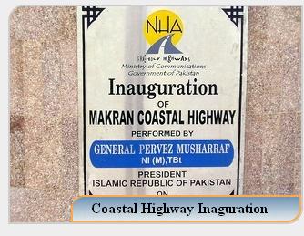
After inauguration by Gen Pervez Musharraf on August 17,
construction work on section-III -- Pasni-Gwadar -- will be started.
By July 1 this year, the FWO has completed following works:
embankment - 105 km, sub-base - 61 km, base - 50 km, black top - 40
km, bridges - 6, culverts - 112 and sinology - 15 km. The start
point of this section is Sajjad Shaheed Chowk, named after an Army
soldier who died during initial reconnaissance, and the end point is
Ormara.
The regional economy of this area is largely based on fishing with
prospects of a substantial growth, following of fish harbour at
several locations ie, Pasni, Gwadar etc. Impetus to the region will
also be provided by the construction of the naval harbour at Ormara
and the third deep-sea port of Pakistan at Gwadar. The construction
of water storage dam on the Hingol River would also result in an
increase in agricultural output in the area.

In addition tourism will also flourish as Makran Coastal Road
project would link Karachi -- the gateway to Pakistan -- with
coastal areas of the country. The Makran Coastal Road would provide
an access to the Naval harbour base at Ormara and would also provide
an easy access to newly emerged central Asian republics.
Makran
Coastal highway is a 700 kilometer newly built road stretching
from Zero point, 40 kilometers from the town of Vinder in
Balochistan right up to Gawadar. So I and my friends Saeed Ahmed
Baig, Muhammad Faisal, Faisal Maqsood decided that we will
travel on this road on 25th December 2004 to pay homage to our
beloved Quaid-e-Azam as well as the engineers and the workers
who have built this marvel for this country.
So we took
off on the morning of Saturday, the 25th of December 2004
exactly at 800 hours from Karachi. We filled our CNG gas tank
and took about 25 liters of petrol with us from Ghani Chowrangi
filling station at SITE Karachi and turned towards the Baloch
city of Hub. We had no destination; the objective was just to
travel on the Makran Coastal Highway. After reaching Hub we had
a good breakfast of parathas, omelets and tea there. It was
chilly but we expected that the weather will become warmer as we
will travel further.
After
traveling 40 Kilometers from the town of Vinder you reach the
zero point. If you wish to travel towards Quetta and Khuzdar you
can go straight ahead or the Makran Coastal Highway is to your
left. We of-course took the left route.
The highway
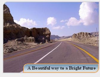
is itself two laned with only wilderness on both sides. One can
have occasional glimpses of the coast and the sea on the right.
The milestones show the towns of Agor and Ormara as the next
destinations.

After
sometime we saw a small hut-tea-hotel and decided to have a cup
of tea there. The owner was a very poor man but very hospitable.
He told us that there is no gas, water or electricity supply
along the highway and he have to travel four or five miles daily
to get water. We however noticed that NLC had laid optical fibre
cable all along the highway.
After
traveling a little further we saw some strange carvings on the
mountains to our right. By looking at them, one can immediately
realize the nature is at work here. We also stopped by to have a
look at the mountainous rocks. A closed examination of the rocks
revealed embedded sea shells and the hut-like carvings over the
small mountains. I think that the entire area was under the sea
sometimes back.
For first
time travelers on this highway, the biggest surprise is that
there are no petrol pumps. As we had limited petrol available
with us we were looking forward to the town of Agor which is
about 220 Kms from Karachi where we hoped that we will find a
fuel station. On reaching Agor, what we found out was that there
was no fuel station, only a couple of shops selling Iranian
Petrol at exorbitant prices and in small quantities. A couple of
car drivers were negotiating for petrol from the shop owners. We
also learned that the first fuel station is at Ormara. The town
of Agor is itself a collection of some shanty houses.
Keeping the
situation of fuel in view we decided that we will only travel a
few miles further just to get a glimpse of the sea and then we
will turn back. Immediately after Agor we had a breath taking
views of the sea. The virgin beaches lined by sand dunes were the
most beautiful.
While we
thought that we have seen it all, a passerby car driver informed
us that if we can drive for about 25 kms we will come across a
place called the Buzi Pass and that we must see it. So there was
no question of not seeing it.
The Buzi pass
is no doubt a wonder in itself. Pakistan engineers have carved a
way through the mountains preserving the beauty of the
mountains. Here one can see one of the most beautiful carvings
in the mountains made by winds and sea over decades. One feels
as if they are looking at some old ruins or excavations. The
most marvelous is a carved structure resembling the shape of the
famous Egyptian Sphinx (known as Abul Hol).

Another worth
seeing carving is that of the Princess of Hope. I donít know who
named it or how but FWO has installed a signboard with this name
on it. There are other structures all along the pass and one gets
an impression of going through some excavation site while passing
through the pass.
Immediately
after the Buzi Pass there is an army camp known as the Ansari
Camp. The milestone showed that we were 265 Kms from Karachi.
There is a mosque here and it seems that this camp is also serving
as a stopover for the travelers of this highway. We also offered
Zuhar prayers here. One of the drivers told us that Ormara is
about 80 kms from here and that we must see it as well. So we
decided that we will also visit Ormara.
The first
formal fuel station is situated at 320 kms from Karachi, a little
outside Ormara. Ormara itself is situated at 340 Kms from Karachi
and is well known for its naval base. We had petrol (of course,
the Iranian one @ Rs. 30 per litre) from here and had a lunch of
fried fish and vegetables.
|
|
|
|
|

