The role played
by Gwadar within the framework of the slave, ivory and
 spive
trade coming from the Arabian peninsula and from East Africa
directed to Central Asia had been crucial since time immemorial.
spive
trade coming from the Arabian peninsula and from East Africa
directed to Central Asia had been crucial since time immemorial.
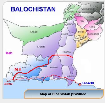
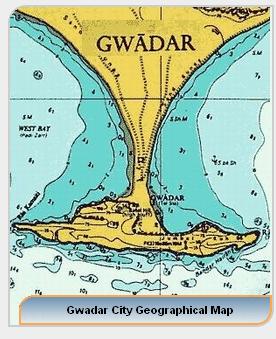
Gwadar includes not
only the town and port but the whole sandy peninsula of that name
covering an area of about 307 square miles. Lying about 290 miles
west of Karachi and 160 miles south-west from Turbat - the capital
of Makran -, this coastal base has been through the ages one of the
main routes of communication between the Middle East and the
Indo-Pakistani sub-continent.
Towards the end of the eighteenth
century Nasir Khan I, of the Ahmadzai family of the Brahui ethnic
group of Kalat "granted" the port of Gwadar to Sultan bin Ahmad
(ruled 1792-1804) of the Al Bu Sa'id tribe of Oman, who escaped from
Maskat (Muscat ) around 1784. Sultan bin Ahmad of the Al Bu Sa'id
maintained this possession also after his accession to the throne of
Maskat. One of the first steps taken by Sultan bin Ahmad of the Al
Bu Sa'id was the nomination of a wali, an Arab deputy (or governor)
at Gwadar, who received the order to build a fort in the best
safeguarded side of Gwadar Bay.
The wali also received the order
from the Omani ruler to conquer Chah Bahar, w hich was captured by
surprise and annexed to the Maskati dominions. The complex question
of the origins and of the juridical value of the "grant" of the port
of Gwadar and its surroundings from Nasir Khan I, Khan of Kalat, to
the Al Bu Sa'id of Maskat as a refuge, but also as a strategic base
for the struggles of power within the Omani tribes, was a
significant subject matter which caused innumerable political
conflicts.
hich was captured by
surprise and annexed to the Maskati dominions. The complex question
of the origins and of the juridical value of the "grant" of the port
of Gwadar and its surroundings from Nasir Khan I, Khan of Kalat, to
the Al Bu Sa'id of Maskat as a refuge, but also as a strategic base
for the struggles of power within the Omani tribes, was a
significant subject matter which caused innumerable political
conflicts.
During the second
half of the nineteenth century, because of the construction of the
Indo-European Telegraph Line, Sir Frederick Goldsmid - Head of the
[Anglo-Persian] Boundary Commission - made investigations in the
Makran area in order to determine the boundaries between Makran,
Sistan and Persia. Territorial and juridical claims were advanced
from all sides directly involved in this serious matter. These
claims gave rise to tensions and struggles, for a long time
unresolved.
Nevertheless, Gwadar
remained an Omani possession as part of the sultanate until
September 1958. Gwadar today belongs to the jurisdiction of the
Government of Baluchistan - Home and Tribal Affairs Department -
within the Makran Division. The African element is still very
evident in this ex-Omani enclave. Within the old Arab-Indian-African
bazaar, there is the ancient Ismaili (Khojas) community centre, as
the Ismailis played a crucial role in the history of the town and
still detain a determined power in the local society.